Cyclone warnings have been issued for more than 4 million people in two states – extending as far south as Grafton in New South Wales – as authorities warn it is “increasingly likely” that Tropical Cyclone Alfred is preparing a destructive arc towards Australia’s east coast.
The Queensland premier, David Crisafulli, said weather modelling from overnight and Monday morning had reinforced the prospect that Alfred would soon veer towards southeast Queensland.
Crisafulli said there was now a “high” likelihood that the storm would reach landfall between K’gari and the New South Wales border, a large stretch of coastline that includes heavily populated areas with about 4 million people, and the city of Brisbane.
The cyclone is forecast to cross the coastline as a category 2 system on Thursday or early Friday. It is now a category 1 system.
Crisafulli said the storm brought three layers of threat to residents largely unaccustomed to a tropical cyclone hitting the coast so far below the tropic of capricorn.
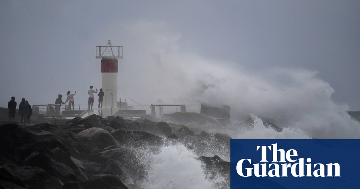
The first was from large surf, tidal storm surge and coastal erosion. Some Queensland beaches recorded waves of up to 14m at the weekend and there is increasing concern for Golden Beach, at the southern tip of the Sunshine Coast, after surging tides cut through the northern tip of Bribie Island.
The island provides a natural barrier that otherwise protects Golden Beach. Without it, there is serious concern about the impact of storm surge.
Crisafulli said there was concern among authorities that the cyclone could cross the coast coinciding with a high tide, which would be particularly destructive along the coast.
A second concern was from damaging winds as the storm nears. The third is from heavy rainfall that would probably concentrate at the southern fringe of Tropical Cyclone Alfred as it crosses the coast.
Authorities have moved to a preparatory footing several days ahead of the predicted impacts, given the potential path of the cyclone includes the heavily populated areas around Brisbane. The Queensland capital is particularly flood-prone and has been severely inundated three times in the past 15 years.
“This is a serious impact,” Crisafulli said.
“The modelling does show that it is likely to cross the coast and we want people to be as prepared as they can be.”
The Bureau of Meteorology has warned that heavy rainfall will be concentrated to the south of wherever Alfred makes landfall, and that the system could bring 300mm to 600mm over multiple days.
Alfred briefly intensified into a Category 2 storm on Monday, before weakening again.
Sue Oates, a senior meteorologist at the bureau, said forecasters expected a “recurvature” of Alfred in the next 24 hours, and that it would “make a westward track towards the Queensland coast on Tuesday morning.”
“It can re-intensify and we are expecting a Category 2 system.”
Oates said there was increasing “confidence” among forecasters of the system crossing the coast on Thursday or early Friday.
While Brisbane and nearby communities begin to prepare, there is an immediate threat of intense winds and potential storm surge in island communities and along the coast.
Decisions have not yet been made about potential school closures or event cancellations. Crisafulli said the state would provide “information” but that many of these decisions would be left to businesses or sporting associations.
The Brisbane lord mayor, Adrian Schrinner, said many of the city’s residents had never experienced a cyclone before as he stressed the “very real threat” to south-eastern Queensland.
It is rare – but not unheard of – for tropical cyclones to reach landfall south of the tropics.
The closest a cyclone track has come to Brisbane was in 1990, when Tropical Cyclone Nancy tracked erratically towards the Queensland capital, before making a southward turn just off the coastline and never reaching landfall.
Tropical Cyclone Wanda – the cause of Brisbane’s historic 1974 floods – crossed the coast near K’gari and Hervey Bay. A severe tropical cyclone crossed the coast near Tweed Heads in 1954.
It is far more common for a tropical cyclone to cross the coast north of the tropic of capricorn and return overland to the south-east as a destructive low storm. This occurred with Cyclone Debbie in 2017.
In NSW, where the northern coastline could be affected, the State Emergency Service urged residents to prepare for damaging winds, large surf and heavy rainfall with major riverine and flash flooding expected from Wednesday.
“We are asking the community to take steps now to ensure that if you are asked to evacuate you have a plan for yourselves, your families and your pets and know where you will go,” NSW SES assistant commissioner Dean Storey said.
The bureau is predicting that Alfred will move slowly to the south-east until Tuesday, before shifting west back towards the coast.
Article by:Source: Ben Smee and AAP